Seagrass Mapping in the Cloud
The Problem
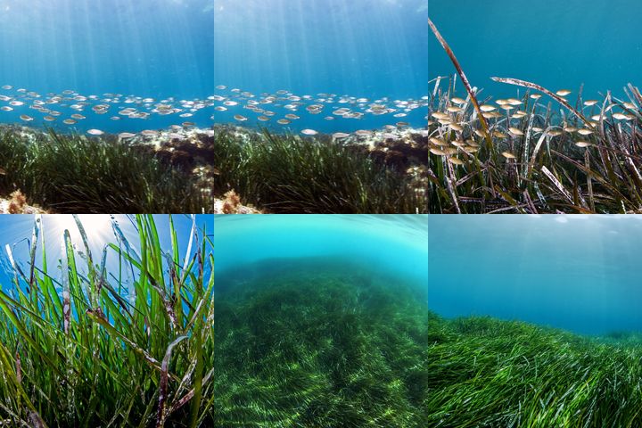
Coastal environments provide a number of ecosystem services and valuable resources for communities and biodiversity alike. Seagrasses provide resilience and sustain coastal communities as they support valuable nurseries and resources to marine biodiversity, they play a role in the food chain, help regulate the quality of coastal waters, and protect coastlines which are directly beneficial to humans and condition the economic development of coastal zones. In addition, seagrasses are important carbon sinks, key indicators of the status of the coastal zone which can be used in coastal management strategies which include climate mitigation. Despite their value, these ecosystems continue to suffer from unsustainable use, pollution, poor water quality, disease and climate change - making humans and wildlife more ever more susceptible to these threats. Conservation managers need timely information to implement active solutions to these issues using the best available scientific information. We propose to produce new satellite-derived datasets to rapidly assess and quantify current status and trends of seagrasses using powerful cloud processing to develop maps, warnings and support future threat scenarios. The geo-spatial data and analyses - distributed via live, interactive online map interfaces will be relevant at both local and national scales to meet the needs of stakeholders in policy and practice on the ground and contribute to knowledge management on coastal ecosystems.
Our Proposal
Mapping seagrasses in near real-time and back in time with satellite imagery will provide an unprecedented source of information for conserving and managing coastal habitats. Until now, most seagrass mapping efforts are manual and effort intensive, and analysts download data and process them using expensive software and hardware or perform complicated field work. We propose to enhance and automate seagrass mapping workflows by connecting crowd-sourced and available field data with Landsat and Sentinel-2 satellite imagery in Google Earth Engine (GEE). GEE is a powerful and free cloud-computing system that affords lightning fast analysis of Petabytes of Earth Observation data. This solution will provide automated and repeatable mapping methods to assess seagrass extent over time, entirely in the cloud. These workflows will be applied in key places with available field data (from local partners and drones) and then scaled up to continental extent. Methods will be published in peer-reviewed articles and shared via a public repository so that anyone can access and apply them to their regions. The workflow will provide new automated methods, specifically adapted to the marine environment for: -image composition to create cloud-free images from the best available pixels; -glint removal to maximize visibility of benthic habitats; -depth-invariant processing to remove the effects of the water column; -machine learning-based seagrass classification and continuous cover products.
We Assume that...
We assume that Google Earth Engine, and satellite imagery from USGS and the Copernicus program remain free of charge to the remote sensing community.
We assume that our existing field data (from local WWF offices, partners, crowd sourcing and drones) are enough to seed the mapping process.
We assume that there will be clear-water imagery at least once a year for adequate mapping and coverage of African coastal ecosystems of interest.
Constraints to Overcome
All the components required to develop accurate and real-time seagrass mapping exist: available imagery, cloud services, technology and software. Yet no one is addressing this major gap by automating processes and workflows as much as possible, and transferring proven methods to new geographies. Also, many think it's simply not possible to map seagrass at large scales from space but we aim to prove otherwise. Our workflow has been proven to work in the Mediterranean (published in June 2018) and Mozambique, two rather different and unique marine environments - however from a satellite perspective they have commonalities, which we will use to scale the effort up to the African continent. The biggest barriers to expanding these efforts are automating and streamlining the process as much as possible to account for the extreme variability of the marine environment.
Current Work
We aim to develop a proven and repeatable workflow for seagrass mapping using free satellite imagery (Landsat and Sentinel-2) and the Google Earth Engine Platform. We will produce multi-temporal seagrass maps for at least 3 time periods for all of Mozambique, using field and drone data, which has never been done before. We will then expand up the coast to Tanzania, and then eventually Africa-wide - mapping seagrasses in at least 5 coastal nations.
Current Needs
In the longer term we are looking for support to scale up the workflow to address tropical seagrasses at the global scale. We could potentially look at temperate grasses and even kelp. We have skilled researchers who are able to work on this, but we require additional resources for staffing and collection of field data where needed to calibrate and validate these new methods. While WWF provides online GIS server use at no cost, we are also looking for additional support for webGIS development to promote our methods, outputs and integrate analysis tools into an online platform.