Species Safari Cam
The Problem
Biodiversity is rapidly declining and protected areas are critical to conservation efforts. Yet the resources for conservation in these areas are often limited and shared amongst competing priorities. Monitoring wildlife to get data on population numbers and trends can help divert limited resources to the right places at the right times. This can help increase the number of species saved. Although a range of monitoring methods exist, from using animal tracks to camera traps, significant resources are often needed to generate reliable density estimates. This makes monitoring difficult to carry out over large areas and repeat, limiting our access to the information needed for fast and effective conservation. For many species and areas, information is sporadic or absent.
Our Proposal
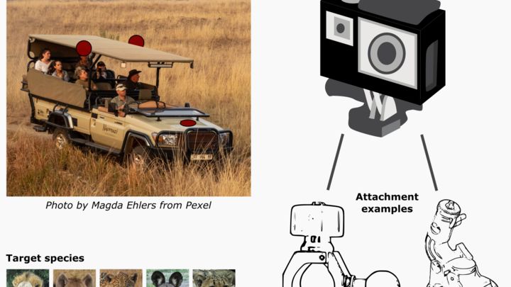
This solution will build upon recent work showing that geotagged wildlife sightings data (records of species and individuals) from safari game drives can be used to estimate wildlife densities (see bit.ly/3cOiFbY). Specifically, we will automate the collection of GPS stamped wildlife images using vehicle mounted cameras, GPS, and edge machine learning. Solar-powered devices will be mounted on safari frames to capture data from 3 directions during game drives (front and sides; one device per direction). Machine learning algorithms designed for running locally on devices will run continuously during game drives and upon detecting one of the target species, will trigger a digital camera to activate and take images of the animal, which will be stored on the device’s internal memory. This solution will initially be developed for African wildlife and will initially focus on large African predators (lion, spotted hyaena, leopard, African wild dog and cheetah). Stored images will be cross-referenced against GPS game drive data to assign coordinates and ‘search effort’ to images – a requirement for estimating densities. Following game drives, the data will then be remotely transmitted to a central base station at the safari lodge, connected to the lodges WiFi. The data will then be sent to researchers for post-processing and density estimation and then shared back with lodges; this process could also be largely automated in future iterations of the solution.
We Assume that...
• End-users are willing to pay for solutions to monitor wildlife resources within their area.
• The safari tourism industry will return following the Covid-19 pandemic.
• We can incrementally adapt the hardware from Raspberry Pi-centric components to more field-suited components (such as using the Jetson Xavier NX as the CPU)
• Suitable vehicle attachment and gimbal mechanisms can be found to limit camera shake caused by vehicles in motion or engines.
Constraints to Overcome
One of the biggest barriers to wildlife monitoring is the resources (e.g. time and money) required to collect and analyse data. This is often addressed through cyclical funding linked to specific research projects, but this limits the scale (spatial and temporal) that monitoring can be carried out. This limits our ability to make fast and effective conservation decisions. Citizen-science has been used in solutions to address this barrier. However, asking volunteers to actively submit data reduces data volumes, and citizen-science data collection/coordination for safari lodges is often traded-off against other priorities (personal observation). By streamlining the data collection process, this solution will provide safari lodges with a tool to monitor wildlife densities as a by-product of activities (safari drives) that they are already doing. This is a novel approach and is enabled by the availability of low-cost GPS and camera modules and newly emerged statistical models.
Current Work
Customer development: interviews with end-users/decision makers at partnering lodges to understand the key features and requirements that they would have for any solutions and opportunities for business models to sustain the project. -- Iterating upon hardware: we will swap out current hardware components in order to build a device that is suitable for field deployment. This includes switching the core processing unit to hardware specifically developed for embedded machine learning applications and adding camera modules with improved resolution and zoom functionality -- Iterating upon software: in line with the hardware iterations, the software will also be updated to build in new functionalities that align with the increased hardware capabilities -- Expanding machine learning: apply transfer learning to existing machine learning models in order to expand the number of species that can be detected and recorded by Species Safari Cam.
Current Needs
(1) Funding for prototyping; (2) access to collaborators/mentors with experience in hardware and product development; (3) access to business mentors who can help with applying the lean start-up methodology to the project and can provide support/advice for searching for sustainable revenue models.