Mapping Marine Debris
The Problem
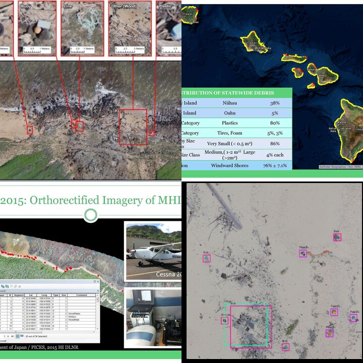
Coastal ecosystems are under constant threat from marine debris, yet our understanding of amount and composition as well as the patterns and rates of accumulation on our shorelines is limited in scale and scope. Better management of marine debris on our shorelines requires better tools for mapping, measuring, and monitoring. While it’s relatively easy to collect imagery, analyzing such large volumes of data can be very slow and subject to errors/bias, thus making it difficult for rapid marine debris detection and response.
Our Proposal
Using machine learning, we are automating the analyses of different types of images: aerial (manned aircraft) ortho-imagery for mapping debris densities and identifying regional hotspots; ground-level (smartphone) photos for real-time debris detection for quick assessments in the field before/after beach cleanups; UAS (drones) photos for quantifying small items (microplastics). We are also developing online platforms to engage citizen scientists in marine debris identification efforts and notify coastal resource managers and community groups with interactive reports (including maps and images). We are building upon baseline data and lessons learned from a previous mapping effort of the main Hawaiian Islands (check the links to our ESRI Story Map and Marine Pollution Bulletin article above). These comprehensive, precise measurements of the quantity, location, type, and size of macro-debris in a wide range of shoreline types are an excellent source of training, test, and validation data to evaluate different machine learning algorithms.
We Assume that...
We need a better understanding of the amount, composition, and location of marine debris to develop strategies for prevention and removal.
Hybrid approaches using machine learning and citizen science can increase the speed and accuracy of image analysis for rapid detection and response to marine debris.
High resolution imagery is an effective method for systematic documentation of marine debris.
The utility of imagery for coastal resource management is limited by its accessibility (large data volumes, high-performance computing, advanced technical expertise).
Constraints to Overcome
Technical expertise in machine learning and developing suitable training data are the main constraints to solving this problem. The solution will require interdisciplinary collaboration with expertise in remote sensing, photogrammetry, GIS, computer vision, and marine debris.
Current Work
[2020] Our team has closed the project and will continue to support partner efforts and collaborate on similar endeavors. [At project inception:] Over the next 3-6 months, our team will: 1) Recruit volunteers for image annotation to improving our training data quality; 2) Run experiments to evaluate new models and analyze new (more current) imagery; 3) Draft report on our progress; 4) Explore other sources of funding
Current Needs
[2020]: None [Project inception:] 1) Funding for cloud computing resources and hosting web apps; 2) Expertise in Microsoft Azure; 3) Labor for reviewing image annotations; 4) Social media expertise for increasing and incentivizing participation in citizen science; 5) Funding for future aerial surveys to produce new ortho-imagery