Cloud-based Bathymetry
The Problem
The seascapes that constitute the coastal environment, including seagrasses and corals, support the livelihoods of over three billion people in more than 100 countries with billions of dollars in revenues through the provision of a plethora of vital ecosystem services - global biodiversity support, carbon dioxide absorption, food security, and coastal protection among others. These coastal fringes of our planet are however undergoing significant pressure due to intense human-made activities like urban coastal development, natural resource exploitation and natural hazards induced by climate change e.g. coastal erosion due to sea level rise. According to the World Economic Forum's 2019 Global Risks Report, 50% of its major risks concern the coastal marine seascape (failure to adapt and mitigate climate change, biodiversity loss and ecosystem collapse, extreme weather events and natural disasters). Failure to meet the goal of 1.5 ºC above pre-industrial levels and related greenhouse gas emission pathways, according to the United Nation's Intergovernmental Panel on Climate Change report, will induce detrimental and irreversible impacts on both these invaluable coastal natural ecosystems as in the neighboring human-related ecosystems at a global scale. Time and cost-efficient global solutions and strategies are therefore required for strengthening our response to the present environmental - and thus societal - challenges.
Our Proposal
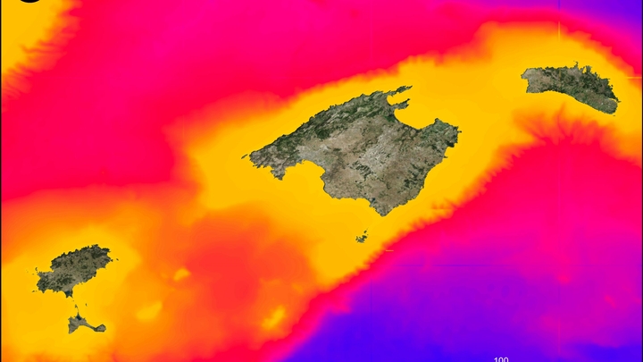
We aim to aid the mitigation of the risks pertaining to the global seascape by developing a fully cloud-based (Google Earth Engine), online satellite-derived bathymetry (SDB) tool leveraging open and free, high-resolution satellite images (Sentinel-2) with low-cost, citizen-derived field data. Accurate and effective mapping of the coastal zone - sea-level change scenarios, risk assessment, and coastal habitat mapping - depend upon available bathymetry measurements. Such measurements have been traditionally collected by expensive, laborious and impractical in shallow waters acoustic systems like single and multibeam echosounders. The advents in cloud geospatial platforms (Google Earth Engine and DIAS), artificial intelligence (machine and deep learning), and open and free satellite image archives (Sentinel and Landsat series), however, unlocks the potential of time and cost-efficient bathymetry estimations in multiple spatial and temporal scales. Here, we exploit the aforementioned advents to propose and develop an open web-based SDB tool which will build on existing and near-future bathymetry datasets via crowdsourcing/citizen data collections and initiatives. Such low-cost in situ bathymetry data are necessary for training and validating the cloud-based workflow outputs - essentially bathymetry maps; and will allow us to ultimately scale up and democratize the estimation of bathymetry globally, all the while assisting the natural and societal challenges that our planet face.
We Assume that...
the cloud geospatial platform of Google Earth Engine will remain free for public use.
the Sentinel-2 data will remain free for public use.
we will manage to identify and integrate a vast plethora of existing field bathymetric data for training and validating our satellite-derived bathymetry.
Constraints to Overcome
Up to now, the majority of takes on bathymetry has featured state-of-the-art methods, softwares with expensive licenses, local servers, datasets acquired by commercial, costly optical (spaceborne and airborne) and acoustic (multibeam) sensors in small regions. All these parameters restricted both the amount of people - in and outside the coastal aquatic research community - that benefited from the respective bathymetry outputs and the scalability of such approaches. Our take will feature an easy-to-use online tool built on open resources - a public cloud geospatial platform and free satellite data. Possessing the technical capacity to develop this tool, we believe that the most important bottleneck in our project is the identification, involvement and integration of existing and/or future low-cost citizen-derived water depth data. These data are integral in the cloud-based bathymetry analysis as they provide the necessary mapping and reference information for more accurate products.
Current Work
Our primary goals and activities over the next three months concern three parts: a) The technological development of the online tool; this part relates to the development of an end-to-end cloud-based satellite-derived bathymetry tool; its subsequent training and validation; and last, its integration into a user-friendly, web-based interface. b) The identification, collection and implementation of further -in addition to the existing field bathymetry datasets in our possesion - low-cost relevant datasets which will improve current accuracies and expand our knowledge and understanding of the pros and cons of our tool. c) The drafting and submission of additional grant proposals which will provide us with the necessary resources to scale up our cloud-based approach into space, time, and data input as well to build a larger team of scientists and collaborators.
Current Needs
In terms of resources, additional funding would allow us to conduct more fieldwork to further test our optical satellite-derived bathymetry algorithms. In terms of skills, additional technical expertise is required to develop the online interface of our tool. Now, the tool runs in the cloud environment of the Google Earth Engine and with the necessary technical effort, we could transform it to a web-based application. In terms of knowledge, we have a solid understanding of the problem and of its solution.