Aerial detection of ROD
The Problem
The most abundant and widespread native tree in Hawaiʻi is ʻŌhiʻa lehua (Metrosideros polymorpha). It helps protect watersheds, serves as habitat for native birds, and has numerous traditional uses in Hawaiian culture. Since 2014, ʻŌhiʻa trees have been dying due to invasive fungal infections known as Rapid ʻŌhiʻa Death (ROD). ROD has impacted all districts of the Big Island, was confirmed in at least 3 different areas on Kauaʻi during 2018, and has the potential to continue spreading statewide. Effective control and containment require early detection methods. However, detecting ROD at landscape scales can be costly, time-consuming, and difficult due to the remote and rugged terrain. Current ROD mapping methods include digital mobile sketch mapping (DMSM), hyperspectral imaging, and drone surveys. DMSM is effective for rapid visual reconnaissance, yet its results are not robust due to positional inaccuracies and observer biases. Hyperspectral imaging is effective for mapping ROD but prohibitively expensive to collect and process. Drone surveys provide a boost to on-the-ground surveys, yet are limited in range and payload capacity. Limited interoperability of different methods result in data of limited use for measuring change or identifying patterns and trends statewide. While ROD infections spread across islands, property boundaries, and habitat types; current methods to measure them do not.
Our Proposal
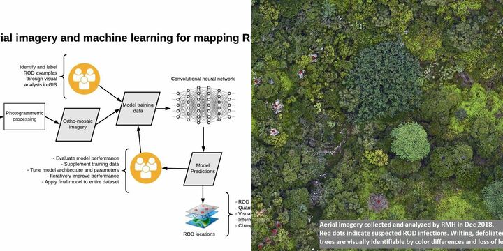
Resource Mapping Hawaiʻi (RMH), Conservation Metrics, Inc (CMI) and The Nature Conservancy of Hawaiʻi (TNC) are teaming up to develop a fast, cost-effective, and robust method to map ROD over large areas of remote and rugged terrain which can be implemented statewide. We will automate the identification of ROD-infected trees in high resolution aerial imagery using a machine learning technique known as Convolutional Neural Networks (CNNs). Successful CNN implementation requires large amounts of training data for accurate results. RMH has already collected and analyzed 5500 acres of imagery on Kauaʻi. However, because ROD only recently appeared on Kauaʻi, that island has fewer examples of infected trees. Therefore, RMH will collect additional ortho-imagery of 5000 acres on the Big Island, where many more ROD infections occur in a variety of habitat types. Including diverse landscapes will ensure the model’s utility for detecting ROD statewide. CMI will convert RMH’s data from Kauaʻi and the Big Island into structures suitable for CNN models. CMI and RMH will generate additional image labels as necessary. CMI will train and evaluate models to detect ROD with optimal sensitivity (percentage of total detections) and accuracy (percentage of false positive detections). CMI will apply the final model to the entire imagery dataset, manually audit model results, and generate locations of ROD detections. TNC’s local knowledge will help verify results.
We Assume that...
Our relatively low cost makes it financially sustainable for statewide ROD response.
Mapping can be conducted when and where managers need up-to-date information.
While aerial surveys inevitably generate carbon emissions, RMH’s fixed-wing aircraft is far more fuel efficient than helicopters.
The ratio of energy use per acre surveyed is far lower than ground-based methods, and much of the upland ʻŌhiʻa forest is virtually inaccessible to field crews without helicopter transport.
High resolution aerial imagery is an effective surveillance method for identifying suspected ROD infections, since defoliation is readily evident to the human eye at resolutions of 3cm or better.
Machine learning can greatly speed up the process of extracting information from imagery and reduce the time lag between data collection and decision making.
Our remote sensing-based method has no negative impacts on biological communities being surveyed nor on any cultural resources.
Plane-based aerial surveys can be conducted infrequently and are less obtrusive to residents or recreators than other survey methods.
The greater range, speed, and payload capacity of airplanes compared to drones allow bigger sensors to collect high quality data over larger areas more quickly.
This method is not only suitable for ROD detection--it can be easily adapted for surveillance of invasive plants.
Constraints to Overcome
Cost is critical for any conservation project, where stakes are high but funding is limited. Survey and monitoring components are often sacrificed to free up money for on-the-ground interventions. However, attempts at controlling ROD without accurate information about where and how the disease spreads will be hindered. Visual analysis of large datasets takes significant time and labor. Machine learning builds upon human efforts and allows analysts to focus on QA/QC of results, thus reducing turnaround time and costs. Quick turnaround facilitates rapid response. Automated aerial imagery analysis enables monitoring ROD at landscape scales repeatedly through time for a few dollars per acre - a fraction of the cost of currently available methods. Managers can then prioritize control efforts where impact will be greatest. Our method becomes more efficient when larger datasets are being collected.