Deep learning nature!
The Problem
The Anthropocene is characterized by fast environmental changes, calling for new approaches to conservation planning, monitoring and management. New conservation paradigms have emerged in order to reconcile nature protection with people’s activities in the wild, namely through recreational activities and inspirational and aesthetic experiences. Nature-based experiences and preferences are crucial to reach the United Nations’ Sustainable Development Goals (SDGs) for 2030, because they encompass many dimensions of human, societal, cultural and economic well-being. Neglecting the value of nature-based experiences and preferences can result, for instance, in losses of cultural identity and heritage, health quality, environmental education, and opportunities for nature entertainment, which could lead to discouraging social support for nature conservation. At the same time, nature-based experiences may also increase human pressure and impact on biodiversity, particularly when applied in a non-sustainable way and when developed in sensitive ecosystems. Therefore, it’s imperative to develop indicators and monitoring systems of nature-based experiences and preferences, in order to support decision making, based on informed management strategies for reaching the SDGs and other sustainability targets.
Our Proposal
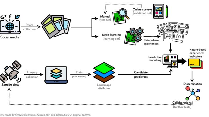
We intend to identify possible indicators for the monitoring of nature-based experiences and preferences, by developing automated classification algorithms on freely available social media data and satellite imagery. We will collect georeferenced pictures shared in social media networks (e.g. Flickr, Instagram). From the set of pictures that are taken outdoors, we will identify key biodiversity and ecosystem attributes that potentially inform on nature-based experiences and preferences (e.g. emblematic species, recreational activities). This identification will be done using deep learning approaches (e.g. Convolutional Neural Networks specifically tailored for our goal) trained and validated considering manual classification of citizen science pictures and online social surveys. We will also use optical satellite imagery (e.g. Sentinel-2, Landsat) to test the predictive power of several satellite-derived variables (e.g. spectral and phenological indices) to characterize biophysical attributes of ecosystems and landscapes (e.g. seasonal color change). Satellite predictors will be tested in modelling frameworks which consider the classified pictures (resulting from deep learning) as multi-class response variables. We expect to achieve a set of satellite variables that can be used as indicators to monitor nature-based experiences and assess their spatio-temporal changes. Our approach will only use freely available data and software (Python, R software, Google Earth Engine).
We Assume that...
We need a better understanding of how to assess nature-based experiences and preferences to support more successful management decisions.
Making use of freely available software and processing platforms, which can deal with large datasets, will make nature-based experiences and preferences monitoring easier for multiple users.
People are drawn to natural structures and elements, as well as to social media, which makes this an incredibly large untapped database that contains useful information.
Recent advances in deep learning and big data analysis has shown the potential of extracting abstract information from imagery and text data with high accuracy using deep neural networks.
Bringing together social media information and freely available high-resolution satellite data can support decision-makers with informed management options in a fast and straightforward manner.
Constraints to Overcome
Assessing nature-based experiences and preferences, as well as integrating them into management decisions, are still challenging tasks. Traditional estimations of how people perceive biodiversity and engage in nature’s activities have been solely based on social surveys, which are often costly, time consuming and context-dependent. Focus on social media “big data”, like pictures shared on Instagram and Flickr, has become a promising approach to explore and understand how people interact with nature. Still, people’s interactions with nature also depend on the features and attributes of ecosystems that allow those interactions to happen (such as terrain accessibility) or that influence people’s preferences (namely, landscape colour diversity). By adding remote sensing data, such as satellite imagery, we can tackle this, helping us to improve our understanding of what underlies nature-based experiences in its biophysical context.
Current Work
Over the next 3-6 months, the team will be dedicated to: 1) collect and analyze social media data based on manual classifications and on the implementation of deep learning algorithms; 2) invite social media users to be part of the study by answering a simple survey to be used for validation; 3) collect and process satellite imagery; and, 4) design a modelling framework that uses satellite information as indicators of nature-based experiences and preferences.
Current Needs
Over the next 3-6 months the project will require: 1) team’s effort on the classification of social media photographs; 2) funding for computing resources (e.g. GPU and neural compute stick) and data hosting; 3) expertise from the social sciences to engage public participation on social surveys; and 4) develop a communication strategy of the outputs and seek collaborations for further tests.